I recently came across a few tid bits that indicate that LORAN is going to continue to be maintained in operation in an enhanced mode (e-LORAN).
It seems it is harder to jam than GPS and can penetrate into difficult environments such as urban-scapes and places hwere there is thick overhead vegitation better than GPS. Apparently it is also continuing in force as e-LORAN in Europe as well.
Anyboady know more?
Peter
LORAN dead..not so fast
Moderators: CaptPatrick, mike ohlstein, Bruce
-
In Memory Walter K

- Senior Member
- Posts: 2912
- Joined: Jun 30th, '06, 21:25
- Location: East Hampton LI, NY
- Contact:
The argument is, and has always been redundancy. A knockout punch / sun spots/ any failure of any sort on the GPS systems would cripple the entire navigational ability of planes, ships and who-knows-what. Not having some form of redundancy is naive, if not insane. I'm old enough to have been trained to navigate by compass, watch and chart, yet I have two GPS', two Lorans and charts on my boat. I'll bet half the boats in my marina don't even have a paper chart on board. There has to be a fallback navigational system as a matter of national security. Sure hope an e-Loran doesn't mean our old ones are invalid. Walter
-
Tony Meola
- Senior Member
- Posts: 6947
- Joined: Jun 29th, '06, 21:24
- Location: Hillsdale, New Jersey
- Contact:
I still have an old micrologic. It served me well for many years. I hope it never dies as it is a great fall back. I also have paper charts and hopefully if I had to, between the depth finder and compass find my way at least close to home. Learned that trick from an old friend who is now long gone. Just have to remember to always check your position on the chart every 15 minutes and if the GPS and loran go out you should be able to get close to home with the compass and depth finder. Tony
-
Harry Babb

- Senior Member
- Posts: 2354
- Joined: Jun 30th, '06, 21:45
- Location: Fairhope Al
- Contact:
I've been all over the Northern Gulf with a SiTex 767. Several years ago when we were diving a lot I found and went back several times to car bodies, airplanes and bridge rubble simply using a Loran, a paper chart recorder and a jug with a weight and stirng.
When DeNada splashes again she will be wearing a new GPS and I will learn how to navigate with new equipment...........never thought about until you guys brought it up but the Loran backup is a good idea........I had pretty much accepted and believed that the Loran towers were going to be shut down
I have a Sextant also............hope I don't have to use it.......not sure I even remember how to use it.
Harry
hb
-
thuddddddd

- Senior Member
- Posts: 1028
- Joined: Jun 29th, '06, 07:42
- Location: N. east Ma, home of fat teddy
Agree with Harry, always have multiple redundant systems. The Blackfin has two GPS and a Loran, along with SSB, Two VHFs, and SAT phone. The same are being installed on the B31, and always, always carry charts. Shoot, I even have a Loran and a GPS on my 25 Hydrasport that I run around the bay in (though I was glad to have them the one time I ran that boat to Block and got caught in a very thick fog).
I still often navigate just by compass and dead reckoning so when the time comes that I have to, I can do it with some confidence. I remember when we got our first radio direction finder! Wow that was so cool, I felt like I was in a WWII spy movie whenever we used that thing on the B25 and then on the dinette of the 1st B31 (an open cabin sportfisherman). Then on that B31 we upgraded to the first Loran A. We had to manually match the sine waves on the old cathode ray tube, good times!
Shoot, I'll even admit this Harry, although you will all laugh at me for it, a few years ago I took a Celestial Navigation course over at the Vanderbilt Planetarium here on Long Island. It was really cool. That Christmas my dad gave me a beautiful brass sextant. I've used it a few times for kicks, but it is kind of neat to know that I have it if the need ever arose (which it won't). I think it is cool that you have one, must be a machinist thing.
After much digression, my point is this- like anything else on a boat you need to be prepared when systems fail, because their is no shoulder to pull over to when you are offshore. Self reliance is key, and admittedly one of the reasons I love being on boats so much.
-
In Memory Walter K
- Senior Member
- Posts: 2912
- Joined: Jun 30th, '06, 21:25
- Location: East Hampton LI, NY
- Contact:
Harry- If you want to find those wrecks again, use the Loran, then mark the spots on your GPS plotter. The Loran translations on GPS' that have them (my Northstar does) are not exact. If you have favorite Loran #'s, go to them via Loran, then punch in the spot on your GPS. That way they'll be exact. And as I've mentioned before, these new chartplotters all have a soldered in little lithium battery inside to retain your waypoints and fishing spots. They should be changed every 5 years or you'll lose them all when you start up one day. I found out the hard way...before 5 years. Keep a hard copy if you can, just in case. Walter
-
Harry Babb
- Senior Member
- Posts: 2354
- Joined: Jun 30th, '06, 21:45
- Location: Fairhope Al
- Contact:
-
Tony Meola
- Senior Member
- Posts: 6947
- Joined: Jun 29th, '06, 21:24
- Location: Hillsdale, New Jersey
- Contact:
Here is one more tip for those of you who have an autopilot. Years ago before chart plotters, an old friend of my fathers compass died on him out in the Hudson Canyon. All of the oil leaked out of it. He just pulled out the paper charts, used the loran to find his spot and dieled the heading home in on the auto pilot.
So remember auto pilots aren't just to keep the boat straight. Unfortunately you can never have enough systems on board to get you home.
So remember auto pilots aren't just to keep the boat straight. Unfortunately you can never have enough systems on board to get you home.
-
Tony Meola
- Senior Member
- Posts: 6947
- Joined: Jun 29th, '06, 21:24
- Location: Hillsdale, New Jersey
- Contact:
Jsezpizio
By the way I remember using an old loran A on a friends 31. Looking in the old scope to line up the lines. That was back before loran C. When we got our 31 back in 75 we had a simrad loran c put on the boat. The damn thing was huge by today's standards. The thing would first flash one line of numbers then the next. Was a real pain as it kept dropping the signle but it somehow always brought us home.
By the way I remember using an old loran A on a friends 31. Looking in the old scope to line up the lines. That was back before loran C. When we got our 31 back in 75 we had a simrad loran c put on the boat. The damn thing was huge by today's standards. The thing would first flash one line of numbers then the next. Was a real pain as it kept dropping the signle but it somehow always brought us home.
-
Tony Meola
- Senior Member
- Posts: 6947
- Joined: Jun 29th, '06, 21:24
- Location: Hillsdale, New Jersey
- Contact:
I found this on Mad Mariner:
eLoran, Game On!
Submitted by BenE on Fri, 02/22/2008 - 12:00.
Remember all the hand wringing about shutting down the Loran system? Well, the inimitable Langhorne Bond was right again; the USCG’s threat was in fact just smart politics. President Bush’s 2009 budget “migrates†Loran responsibility from the Coast Guard to another Dept. of Homeland Security (DHS) unit called the National Protection and Programs Directorate (NPPD). The budget further states that NPPD will be responsible for finishing the transformation of Loran-C to Enhanced Loran (eLoran). On Feb. 7, DHS announced eLoran will not only back up marine and aviation GPS navigation, but enhance navigation for “first responders†and others operating in difficult GPS environments. This is a big deal.
But I had missed this story until a young (relatively) gentleman named Zachariah Conover sought me out at MIBS. Conover is a founder of CrossRate Technology, which has developed a serious looking Integrated GPS/Loran Receiver that’s just about ready to go. And how about this good fortune: Conover grew up on Isleboro Island (which you’d see left in the Panbo header photo if it were much wider angle), and his company is near Portland. In other words, it’s going to be easy to see what CrossRate is up to, and learn more (than I have so far) about how eLoran will make electronic navigation “belt and suspenders†reliable.
PS The issue of continued USCG HF weather broadcasts was also favorably resolved just recently. Wouldn’t it be a glorious trifecta if the FCC does right next week!
-
Harry Babb
- Senior Member
- Posts: 2354
- Joined: Jun 30th, '06, 21:45
- Location: Fairhope Al
- Contact:
Walter
In the summer of 2002 one of my dive buddies purchased a boat and he outfitted it with GPS. He purchased some sort of software that was supposed to convert the Loran TD's to Long-Lat numbers.............well it did not work at all. We blew most of a day looking for spots. Some of them were as near as we could GUESS.......a quater of a mile off.
After we found the first spot we estimated that the numbers were off by a quater mile in the SSW direction. So now we are off to find other spots and discover that our....go to the number then turn and go in a SSW direction does not work.
On a later trip we took both boats and did just as you described.....worked great.
We sometimes share and trade numbers within our Diving/Fishing group. We have found that 2 idendical Loran's do not read the same. Two boats with identical SiTex Lorans sitting side by side over a spot sometimes would read as much as 1-1/2 microseconds different. I was wondering if GPS's read closer to the same..........from one machine to another????
Another situation that we have had to deal with is Hurricanes moving our stuff around. The government placed a lot of Army Tanks in the Gulf for artificial reefs. Believe it or not Hurricane Ivan MOVED this one particular Army tank and flipped it upside down.............in 80 feet of water. I found that amazing.
Harry
hb
-
In Memory Walter K
- Senior Member
- Posts: 2912
- Joined: Jun 30th, '06, 21:25
- Location: East Hampton LI, NY
- Contact:
As I understand it, the accuracy of these instruments (+/- 50 ft, etc.) is based on the repeatability of an individual unit. Marked and returned to with the same unit. There IS a way to adjust two units to read the same by adding or subtracting a microsecond, and it's usually buried in one of the instruction books. It only makes sense if it's two instruments on the same boat, or two instruments with their antennas positioned in almost the same place. Walter
Loran
Tony Meola, we used to use an RDF because we could not afford the Loran "A" and it was so big, i did not have any room for it. My first Loran was the TI9000 which showed 1 TD at a time for about 5 seconds, then we would plot our location and then figure out our next course. The stuff they have out there today is just great. I wonder what tomorrow will bring.
-
Tony Meola
- Senior Member
- Posts: 6947
- Joined: Jun 29th, '06, 21:24
- Location: Hillsdale, New Jersey
- Contact:
Ed C.
Actually, my friend who showed me how to use a loran A on his 31 bought the loran, after trying to come home from the canyon in a bad storm with the RDF. Missed the inlet by 20 miles. When he realized were he was he made a line for home. He ran out of gas just as he cleared the jetty's at Barnegat inlet. The next week he had the loran A.
In fact his boat got sold to someone down in the Wildwood area.

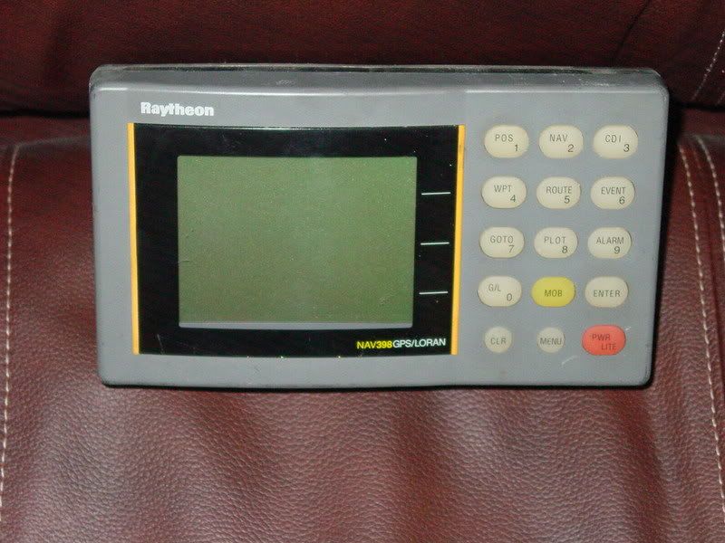
This little beauty is just about the best little navigation unit I have ever used. Too bad it is discontinued.Tony Meola wrote: which has developed a serious looking Integrated GPS/Loran Receiver that’s just about ready to go..
The Raynav 398 GPS/Loran. Also wired for D-GPS as well.
This unit would read both GPS and Loran and display in either TD's or Lat/Long, whichever way you wanted to program it.
All I need now is a new battery for the Loran sensor, as Walter said, they go bad in about 5 years.
Harv
LORAN is less accurate, but more repeatable. GPS is better in accuracy, but not as repeatable. That is, if you go to a spot and mark it on your LORAN...even if the spot doesn't plot perfectly on the chart as your exact position, when you return t othe same td's (using the same LORAN on the same boat) you will be excatly in that same spot again.
GPS on the other hand will put you close, but even tied to the dock you can watch the position information wander around a little as the satellites pass and the geometry changes, though these days it isn't much anymore.
I also like the fine TD lines printed on paper charts. It makes it really easy to do an accurate thumbnail plot without having to dig out dividers and teh parallel rules.
I often wondered as they "phased out" LORAN why they didn't do a similar overlay printing of LAT LON lines for GPS use...but now I guess I know why.
I think I'll dig that old LORAN unit I have back out of storage, and see about remounting that old antenna. Glad I didn't chuck it after all.
BTW when all else fails and you are on compass and watch, don't forget to use the depth sounder too. I've navigated to more than one narrow harbor entrance in thick fog by getting close and then running along a particular contour line until I found the channel entrance.
Peter
-
Tony Meola
- Senior Member
- Posts: 6947
- Joined: Jun 29th, '06, 21:24
- Location: Hillsdale, New Jersey
- Contact:
Harv
I think one of the manufactures still has a combo unit. I haven't seen it advertised, but I bet they start showing up again.
Ed C:
Back in the day, all the lightship buoys had RF signals you could home in on. Those days are long gone. In fact I think I threw our old RDF out about 6 years ago when I found it buried in the closet. I remember buying it back in 1975 when we first got the boat.
Tony
-
In Memory of Vicroy

- Senior Member
- Posts: 2340
- Joined: Jun 29th, '06, 09:19
- Location: Baton Rouge, LA
I have one of the Raytheon 398's on AJ along with a bunch of other GPS units. I checked the LORAN function on the 398 not long ago and it works fine, altho I usually leave it on the GPS mode since it drives my B&G large digit repeater on the dash....all obsolete after the Garmin 2010C came aboard. The LORAN function on the 398 needs a separate antenna and coupler to work.
Talking about RDF, I still have my old Raytheon with the spin antenna on top run by a couple of 6v lantern batteries.....we used to have a couple of low freq. NDB beacons at the mouth of the Miss. River, and I could usually find the United States with the damn thing. I used RDF off NDBs a lot when I flew as a pilot and hated them too. My first LORAN was an "A" with a scope and you had to fiddle with knobs to put the correct signal image on a little "stool" then read the TDs off the windows behind the knobs...write it down, then do the cross TDs to get a fix...toook about 10 minutes to do a fix, was good to about 5 miles if you were sitting still. Then got my first LORAN C, a Sitex the size of a small suitcase with a one line TD reading, but would cross track, the cat's meow if you could think in micro-seconds...then the real deal, the Sitex 7 somthing that had two lines, a Z80 computer chip and would convert TDs into L/L and had 9 memory slots, yep, 9....I paid $1,800 for it and that sucker took me all over the Gulf of Mexico with total confidence. Cross track in nautical miles, time to waypoint, speed, you name it....the current ones don't do anything better, other than the chart plotters that show where you are on a map vs. you looking at a paper chart. I love the Garmin 2010C, but keep all the other stuff since its there and works. Like my old Raytheon 600 chart plotter that overlays on the radar....hard to see since the screen is green and letters real small, but it works...driven by a Garmin GPS in the back of the overhead electronics box I can just see to punch the "on" button.
In the old days we would buddy boat out of Port Eads with a compass, a watch and a grease chart and plot our way out and quit fishing about 2 pm to try and find land before it got dark at 8 pm, some 25 miles offshore...we usually stayed lost, me fiddling with my RDF, the buddy boat saying he sees the lighthouse, us going with him, and the lighthouse he saw was one abandoned in 1783 by the French about 15 miles off course.
I like the good new days.
UV
-
In Memory Walter K
- Senior Member
- Posts: 2912
- Joined: Jun 30th, '06, 21:25
- Location: East Hampton LI, NY
- Contact:
I still have an Apelco RDF unit connected to my VHF. I use it when I hear boats that are into fish, but won't say where they are. Gives me their bearing from me. Have also used it to find/help guys lost in a fog. Keep them talking to me and the rdf gives me their direction from my boat. Between that and my radar, once found, they follow me back in. Walter
-
Brewster Minton

- Senior Member
- Posts: 1795
- Joined: Jun 30th, '06, 07:44
- Location: Hampton Bays NY
- Contact:
Who is online
Users browsing this forum: Bing [Bot], Google [Bot] and 364 guests