Tropical storms forecasts

The Main Sand Box for bertram31.com

Moderators: CaptPatrick, mike ohlstein, Bruce

Navatech

Tropical storms forecasts

Post by Navatech »

Currently there are two "disturbances":

Image

One is already a named Tropical Storm (Gaston):

Image

The other one, to be called Hermine if and when it turns into a Tropical Storm (currently there's a 60% chance of that):

Image

Be safe out there brothers!...

P.S. If anybody knows how to put up the special hurricane threads, please move this post there...
Navatech

Re: Tropical storms forecasts

Post by Navatech »

http://www.nhc.noaa.gov/gtwo.php?basin=atlc&fdays=2

Tropical Weather Outlook Text

ZCZC MIATWOAT ALL
TTAA00 KNHC DDHHMM

TROPICAL WEATHER OUTLOOK
NWS NATIONAL HURRICANE CENTER MIAMI FL
800 AM EDT WED AUG 24 2016

For the North Atlantic...Caribbean Sea and the Gulf of Mexico:

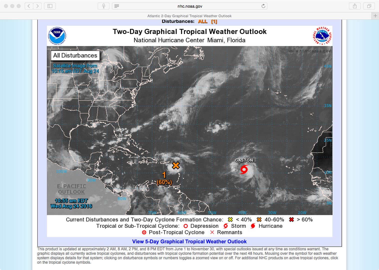
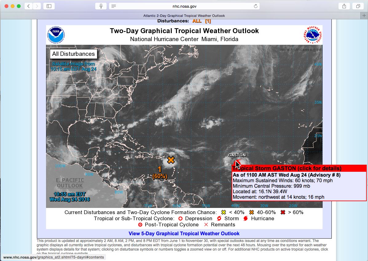
The National Hurricane Center is issuing advisories on Tropical
Storm Gaston, located about 1000 miles west of the Cabo Verde
Islands.

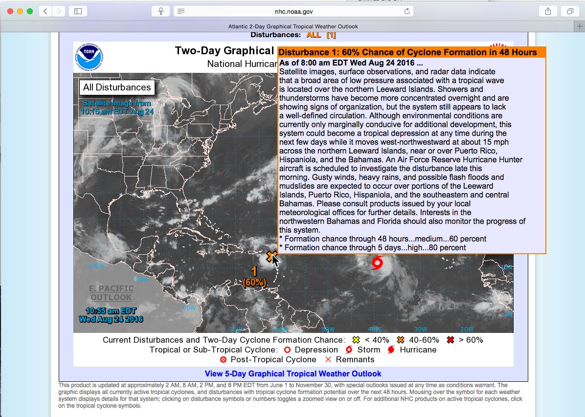
1. Satellite images, surface observations, and radar data indicate
that a broad area of low pressure associated with a tropical wave
is located over the northern Leeward Islands. Showers and
thunderstorms have become more concentrated overnight and are
showing signs of organization, but the system still appears to lack
a well-defined circulation. Although environmental conditions are
currently only marginally conducive for additional development, this
system could become a tropical depression at any time during the
next few days while it moves west-northwestward at about 15 mph
across the northern Leeward Islands, near or over Puerto Rico,
Hispaniola, and the Bahamas. An Air Force Reserve Hurricane Hunter
aircraft is scheduled to investigate the disturbance late this
morning. Gusty winds, heavy rains, and possible flash floods and
mudslides are expected to occur over portions of the Leeward
Islands, Puerto Rico, Hispaniola, and the southeastern and central
Bahamas. Please consult products issued by your local
meteorological offices for further details. Interests in the
northwestern Bahamas and Florida should also monitor the progress of
this system.
* Formation chance through 48 hours...medium...60 percent
* Formation chance through 5 days...high...80 percent

Forecaster Brown
Tony Meola
Senior Member
Posts: 6929
Joined: Jun 29th, '06, 21:24
Location: Hillsdale, New Jersey
Contact:

Re: Tropical storms forecasts

Post by Tony Meola »

Here we go.

I heard today that this one is positioned and set up to take off just like a Andrew. The claim conditions are the same.
1975 FBC BERG1467-315
Navatech

Re: Tropical storms forecasts

Post by Navatech »

Tony Meola wrote:I heard today that this one is positioned and set up to take off just like a Andrew. The claim conditions are the same.
I've heard the same talk... How much of it is due to to timing and the trauma left by Andrew is anybody's guess...

Be that as it may, the unnamed disturbance has actually gone down from 60% to 50% chance of forming a cyclone...
Navatech

Re: Tropical storms forecasts

Post by Navatech »

Cyclone formation chances for the next 48 hours is still 50%...

Cyclone formation chances for the next 5 days is 80%...
Navatech

Re: Tropical storms forecasts

Post by Navatech »

Cyclone formation chances for the next 48 hour has gone down to 30%...

Cyclone formation chances for the next 5 days is 60%...

Current position is between the southeastern tip of Cuba and the Turks and Caicos and it seems to be headed for the GOM via the FL straits...

Gaston is a category 2 currently northeast of Bermuda and swinging into the north Atlantic...

A new disturbance with a 10% chance of developing into a storm is roughly in the center of the GOM...
Tony Meola
Senior Member
Posts: 6929
Joined: Jun 29th, '06, 21:24
Location: Hillsdale, New Jersey
Contact:

Re: Tropical storms forecasts

Post by Tony Meola »

Season is heating up.
1975 FBC BERG1467-315
User avatar
Rawleigh
Senior Member
Posts: 3433
Joined: Jun 29th, '06, 08:30
Location: Irvington, VA

Re: Tropical storms forecasts

Post by Rawleigh »

Nav: Thanks for keeping everyone informed. Pat used to do that and it kept many of us who are not meteorologically savvy from being surprised. I hope you will keep it up. Rawleigh
Rawleigh
1966 FBC 31
Navatech

Re: Tropical storms forecasts

Post by Navatech »

Rawleigh wrote:Nav: Thanks for keeping everyone informed. Pat used to do that and it kept many of us who are not meteorologically savvy from being surprised. I hope you will keep it up. Rawleigh
I'll do my best... Hopefully the "web masters" will give me the permissions that will allow me to create the specific threads that Capt. Pat used to do...

Having said that, here's the link for the Atlantic 2 day forecast: http://www.nhc.noaa.gov/gtwo.php?basin=atlc&fdays=2

And I'd like to remind everybody that it's THEIR responsibility to check their local weather before setting out on the water...
Navatech

Re: Tropical storms forecasts

Post by Navatech »

Disturbance # 1 is off the coast of Texas... Currently a 10% of cyclone formation in the next 48 hours...

Disturbance # 2 is off the coast of Africa... Currently a 0% of cyclone formation in the next 48 hours...

This tropical depression # 8:

Image

And this is tropical depression # 9:

Image
Tony Meola
Senior Member
Posts: 6929
Joined: Jun 29th, '06, 21:24
Location: Hillsdale, New Jersey
Contact:

Re: Tropical storms forecasts

Post by Tony Meola »

#8 is due to hit the Carolina's in the next two days so heads up.

#9 looks interesting since it could reform in the Atlantic.
1975 FBC BERG1467-315
Yannis
Senior Member
Posts: 2983
Joined: Oct 23rd, '13, 09:41
Location: Athens, Greece

Re: Tropical storms forecasts

Post by Yannis »

Nav,

You have to establish all links for the weather in the eastern med, the Aegean more specifically....!

It's been an extremely windy summer, to give you an idea, last year I had cruised 700 miles until now, this year only 330.
Terrible, up to 40+ knot winds around ALL islands.... Stayed in port most of the time, without internet but with a lot of friends and family.
1973 B28 FBC/2007 4LHA STP's - "Phantom Duck" - Hull "BER 00794 1172"
Navatech

Re: Tropical storms forecasts

Post by Navatech »

Yannis wrote:You have to establish all links for the weather in the eastern med, the Aegean more specifically....!
I know the Greek don't get along too well with the Turks (who does? especially under Sultan Erdogan?) but here's 2 links:

http://www.mgm.gov.tr/en-us/marine-metu3-wind.aspx?d=da

http://www.mgm.gov.tr/en-US/marine-metu ... p&b=Aegean

Here's a few more:

http://passageweather.com (clickable map)

http://www.myweather2.com/Marine/Coasta ... W/map.aspx (clickable map)

http://www.poseidon.hcmr.gr/sailing_for ... ea_id=saeg
Yannis wrote:with a lot of friends and family.
That's what it's all about anyway!... Think about all the fuel you're saving ;-)))
Tony Meola
Senior Member
Posts: 6929
Joined: Jun 29th, '06, 21:24
Location: Hillsdale, New Jersey
Contact:

Re: Tropical storms forecasts

Post by Tony Meola »

Heads up Outer Banks. You are going to get a one two punch. Right after #8 passes, #9 is going come visiting. Looks like a lot of rain and wind. It is not expected to turn into a Hurricane.
1975 FBC BERG1467-315
Yannis
Senior Member
Posts: 2983
Joined: Oct 23rd, '13, 09:41
Location: Athens, Greece

Re: Tropical storms forecasts

Post by Yannis »

Nav, you're a nerd alright !! Thanx.
1973 B28 FBC/2007 4LHA STP's - "Phantom Duck" - Hull "BER 00794 1172"
Tony Meola
Senior Member
Posts: 6929
Joined: Jun 29th, '06, 21:24
Location: Hillsdale, New Jersey
Contact:

Re: Tropical storms forecasts

Post by Tony Meola »

Update

#9 is expected to strengthen to Hurricane status as it approaches Florida.
1975 FBC BERG1467-315
Navatech

Re: Tropical storms forecasts

Post by Navatech »

Disturbance # 9 is officially a category 1 hurricane... Hermine is currently making landfall in the northeast corner of the GOM (FL Big Bend)...

Image
User avatar
mike ohlstein
Site Admin
Posts: 2382
Joined: Jun 29th, '06, 11:39
Location: So many things seem like no-brainers until you run into someone with no brain.
Contact:

Re: Tropical storms forecasts

Post by mike ohlstein »

Bertram Weather......

ANZ815-022000- SOUTH OF LONG ISLAND BETWEEN MONTAUK POINT AND SANDY HOOK TO 1000 FM- 443 AM EDT FRI SEP 2 2016 TROPICAL STORM WARNING

TODAY N TO NE WINDS 5 TO 15 KT. SEAS 3 TO 5 FT.

TONIGHT E WINDS 5 TO 15 KT. SEAS 3 TO 5 FT.

SAT E WINDS INCREASING TO 20 TO 30 KT. SEAS BUILDING TO 6 TO 10 FT. ISOLATED SHOWERS AND TSTMS.

SAT NIGHT E WINDS INCREASING TO 25 TO 35 KT. SEAS BUILDING TO 12 TO 20 FT. SCATTERED SHOWERS AND ISOLATED TSTMS.

SUN E TO NE WINDS 30 TO 40 KT. SEAS BUILDING TO 15 TO 28 FT.

SUN NIGHT E TO NE WINDS 35 TO 45 KT. SEAS 16 TO 26 FT.

MON E TO NE WINDS 35 TO 45 KT. SEAS 12 TO 22 FT.

MON NIGHT E TO NE WINDS 30 TO 40 KT. SEAS 14 TO 23 FT.

TUE E TO NE WINDS 35 TO 50 KT. SEAS 15 TO 25 FT.

TUE NIGHT E TO NE WINDS 40 TO 50 KT...DIMINISHING TO 35 TO 45 KT. SEAS 13 TO 22 FT.
Mike
Mean Team Leader
PREDATOR

Burn Oil
Eat Food
1973 FBC 1286 0273-315
Tony Meola
Senior Member
Posts: 6929
Joined: Jun 29th, '06, 21:24
Location: Hillsdale, New Jersey
Contact:

Re: Tropical storms forecasts

Post by Tony Meola »

There goes my week at the beach.
1975 FBC BERG1467-315
Navatech

Re: Tropical storms forecasts

Post by Navatech »

As of 0200 both Gaston and Hermine have been downgraded to tropical storms...
User avatar
Dug
Senior Member
Posts: 2256
Joined: Jun 29th, '06, 11:04
Location: Worcester, MA

Re: Tropical storms forecasts

Post by Dug »

That's Bertram weather for sure. I'm wondering how fun it's going to get inside Fishers Island sound...gonna get gusty either way!!!
Tony Meola
Senior Member
Posts: 6929
Joined: Jun 29th, '06, 21:24
Location: Hillsdale, New Jersey
Contact:

Re: Tropical storms forecasts

Post by Tony Meola »

It is blowing pretty good down here in Ocean county nj. So far the tide in our lagoon is only about a foot above normal. With sandy, by now it was ,2 feet higher.
1975 FBC BERG1467-315
Navatech

Re: Tropical storms forecasts

Post by Navatech »

Gaston has now completely spun out and no longer exists...

Hermine is now a post-tropical cyclone and will follow Gaston shortly...

A little east of the Lesser Antilles we have a new disturbance (# 1) which currently has a 20% chance of cyclone formation for the next 48 hours and a 30% for the next 5 days...
User avatar
Bertramp
Senior Member
Posts: 1429
Joined: Jan 2nd, '09, 14:57
Location: Sag Harbor, NY Fort Lauderdale, FL
Contact:

Re: Tropical storms forecasts

Post by Bertramp »

Left Sag Harbor this AM, was in Montauk yesterday.
Sitting in Mineola (mid-island/central Nassau), you would never know that it's ROCKIN' out east !!
White-caps inside of Cedar Point, not a boat on the water in Gardiner's Bay yesterday and only surfers out in the ocean (the real surfers, not the folks that just ride around with boards on their cars)
1970 Bahia Mar - hull# 316-1003
1990 Blackfin 27 - center console
Steve "Bertramp" Kelly
Navatech

Re: Tropical storms forecasts

Post by Navatech »

Image

ZCZC MIATWOAT ALL
TTAA00 KNHC DDHHMM

TROPICAL WEATHER OUTLOOK
NWS NATIONAL HURRICANE CENTER MIAMI FL
800 PM EDT SAT SEP 10 2016

For the North Atlantic...Caribbean Sea and the Gulf of Mexico:

1. An area of low pressure located about 1000 miles east of the Lesser
Antilles is moving slowly northwestward. Satellite imagery
indicates that the circulation has become better defined today, but
the associated thunderstorm has not become any better organized in
the past few hours. Conditions are still favorable for a tropical
depression to form by during the next day or two while this
disturbance moves toward the northwest over the central Atlantic.
* Formation chance through 48 hours...high...80 percent
* Formation chance through 5 days...high...90 percent

2. An area of cloudiness and thunderstorms located north of Hispaniola
remains disorganized. There are no signs of a surface circulation,
and conditions are not expected to be conducive for significant
development of this system while it moves generally west-
northwestward at around 15 mph.
* Formation chance through 48 hours...low...10 percent
* Formation chance through 5 days...low...10 percent

3. A weak area of low pressure located over the extreme southeastern
Gulf of Mexico remains devoid of thunderstorm activity. Upper-level
winds are not favorable for development, and the low is forecast to
weaken while it moves westward to west-southwestward at 5 to 10 mph
into the central Gulf of Mexico during the next day or two.
* Formation chance through 48 hours...low...10 percent
* Formation chance through 5 days...low...10 percent

Forecaster Brennan
Navatech

Re: Tropical storms forecasts

Post by Navatech »

We have a new tropical storm: Matthew...

Image

Image
User avatar
Rawleigh
Senior Member
Posts: 3433
Joined: Jun 29th, '06, 08:30
Location: Irvington, VA

Re: Tropical storms forecasts

Post by Rawleigh »

Two of the best models are taking this along the track of Hazel from 1954, so heads up everyone!!! Still too early to tell what it will do, but forewarned is forearmed!!
Rawleigh
1966 FBC 31
Tony Meola
Senior Member
Posts: 6929
Joined: Jun 29th, '06, 21:24
Location: Hillsdale, New Jersey
Contact:

Re: Tropical storms forecasts

Post by Tony Meola »

Mathew is now a Hurricane. The path is unclear, it could still swing up into the gulf or head up the east coast. Keep an eye on this one guys. If the rain in the North East hangs on too long, it will gut sucked inshore and up the coast.
1975 FBC BERG1467-315
Navatech

Re: Tropical storms forecasts

Post by Navatech »

Tony Meola wrote:Mathew is now a Hurricane. The path is unclear, it could still swing up into the gulf or head up the east coast. Keep an eye on this one guys. If the rain in the North East hangs on too long, it will gut sucked inshore and up the coast.
Matthew started out as a tropical depression, turned into a tropical storm, turned into a category 1 hurricane and is now a category 2 hurricane...

Keep an eye on this one guys!... Especially if you happen to be in Cuba or the Bahamas...

Image
User avatar
JeremyD
Senior Member
Posts: 269
Joined: Jan 20th, '09, 09:36
Location: ST. PETE, FL

Re: Tropical storms forecasts

Post by JeremyD »

Image
1977 B31 (315 Cummins) Build thread --->https://www.thehulltruth.com/boating-ho ... model.html
2010 Key West Bay Reef | 150 Yamaha
1986 Bertram 28 260 Mercruisers [SOLD]
Navatech

Re: Tropical storms forecasts

Post by Navatech »

Hurricane Matthew is now a big boy as a Category 4 hurricane...

Be careful out there friends... And if you live in Jamaica, Cuba or the Bahamas - I hope you had your plan and supplies ready because it looks like you're going to need them... It's certainly time to put up the shutters or plywood or whatever your plan calls for...

What did the hurricane say to the coconut tree?!...

Hold on to your nuts, this is going to be one hell of a blow job!...
Tony Meola
Senior Member
Posts: 6929
Joined: Jun 29th, '06, 21:24
Location: Hillsdale, New Jersey
Contact:

Re: Tropical storms forecasts

Post by Tony Meola »

Cranked up to a cat 5. Heads up everyone. Looks like everything from Cuba north is on this ones potential hit list. Could be up hear in the NE by the end of the week.
1975 FBC BERG1467-315
Navatech

Re: Tropical storms forecasts

Post by Navatech »

Tony Meola wrote:Cranked up to a cat 5.
With winds of 160 knots this bad boy is now a Category 5 hurricane... This is definitely a bad one... Jamaica, Cuba and the Bahamas are going to get hammered... SEF (South East FL) isn't in the clear yet either... Heavy rain reports from Marathon...

Image

Image
Navatech

Re: Tropical storms forecasts

Post by Navatech »

Some more models:

Image

Jamaica, Haiti and Cuba are definitely going to get hammered... The Dominican Republic is going to get lots of rain... Whether it's the Bahamas and or SEF that are going to follow depends on how things develop...

Image

Factoid: although hurricane Matthew (currently at the high end of a Category 4 hurricane) was the 1st Atlantic hurricane to reach Category 5 since Felix of 2007...
Navatech

Re: Tropical storms forecasts

Post by Navatech »

BTW, the NHC Atlantic Ops center of the National Weather Service has a twitter feed: https://twitter.com/NHC_Atlantic
SteveM
Senior Member
Posts: 657
Joined: Jul 3rd, '06, 22:14
Location: Man-O-War Cay, Bahamas

Re: Tropical storms forecasts

Post by SteveM »

Here's a good site with lots of animated models: [url http://www.tropicaltidbits.com/analysis/models/[/url]
Duchess is here in FL. Praying the house come through this OK.
Steve Marinak
Duchess - 1973 Sportfisherman
User avatar
Charlie J
Senior Member
Posts: 2207
Joined: Jun 29th, '06, 09:14
Location: freeport n.y

Re: Tropical storms forecasts

Post by Charlie J »

everyone in the way stay safe
1968 hull # 316 - 757
Tony Meola
Senior Member
Posts: 6929
Joined: Jun 29th, '06, 21:24
Location: Hillsdale, New Jersey
Contact:

Re: Tropical storms forecasts

Post by Tony Meola »

Hopefully it will getsuckedupbetweenthe two pressure systems and then it is out of Dodge fast.
1975 FBC BERG1467-315
Navatech

Re: Tropical storms forecasts

Post by Navatech »

Right now nobody knows where it's going... The models are all over the place:

Image
Preston Burrows
Senior Member
Posts: 264
Joined: Jun 29th, '06, 13:30
Location: Nassau,Bahamas
Contact:

Re: Tropical storms forecasts

Post by Preston Burrows »

Hard-a-starboard please!
Preston Burrows
1976 B28 FBC
BERF1398M76J-285
Navatech

Re: Tropical storms forecasts

Post by Navatech »

Preston Burrows wrote:Hard-a-starboard please!
Pray (if you believe in that sort of thing) harder!

Image
User avatar
Charlie J
Senior Member
Posts: 2207
Joined: Jun 29th, '06, 09:14
Location: freeport n.y

Re: Tropical storms forecasts

Post by Charlie J »

heads up n Carolina guys
1968 hull # 316 - 757
Navatech

Re: Tropical storms forecasts

Post by Navatech »

Matthew is moving slowly... Still a Category 4 hurricane... Current track has moved west...

Image
Navatech

Re: Tropical storms forecasts

Post by Navatech »

Right now Haiti is getting hammered... Cuba is next... Gitmo was partially evacuated... The Bahamas are going to get hammered... SEF might be... Depending on the exact track...

https://earth.nullschool.net/#current/w ... 20.09,2174
User avatar
Rawleigh
Senior Member
Posts: 3433
Joined: Jun 29th, '06, 08:30
Location: Irvington, VA

Re: Tropical storms forecasts

Post by Rawleigh »

I'm not liking this one!
Rawleigh
1966 FBC 31
User avatar
Dug
Senior Member
Posts: 2256
Joined: Jun 29th, '06, 11:04
Location: Worcester, MA

Re: Tropical storms forecasts

Post by Dug »

Neither do I.

Alchemy is coming out tomorrow. I am running her a ways up the CT river to the Chester Marina. I think better safe than sorry...

D
Navatech

Re: Tropical storms forecasts

Post by Navatech »

Matthew's forecasted track is still moving westward... It looks like the eastern coast of Florida is going to get hit too...

Image

AND we have a new tropical storm... Nicole... Luckily right now she's way eastward of land but who knows where she'll be going...

Image

Image
User avatar
Capt.Frank
Senior Member
Posts: 641
Joined: Jun 29th, '06, 21:20
Location: Kill Devil Hills,NC

Re: Tropical storms forecasts

Post by Capt.Frank »

I sure hope this storm goes west more or a lot more east would be great. Eastern NC has had 15+" of rain last month. If we get high winds and another 12"+ rain from this there is going to be a lot of damage. Hatteras got flooded last month from tropical storm. If Matthew hits us as a strong 2 might get some new inlets. He also better start speeding up. We don't need a slow storm.
1976 FBC
3208 NA
Navatech

Re: Tropical storms forecasts

Post by Navatech »

Matthew is still moving westward... In the past 48 hours, the projected path has moved 250 miles west...

Image

Rick Scott (FL Governor) has declared a state of emergency...

Post Reply

Who is online

Users browsing this forum: No registered users and 34 guests